Free Truck GPS App: What Highway Miles Includes—and What to Know
A practical guide to the free phone plan, optional Ad-Free subscription, route planning and the limits drivers should understand.
Last updated: October 10, 2026.
Originally published: October 3, 2026.
Yes—Highway Miles provides ongoing, free phone-based truck navigation. The free plan is ad-supported, and a navigation subscription is not required. The optional Ad-Free plan is currently advertised at $5.99 per month. It removes in-app advertising; the released phone-navigation tools described in this guide are included in both plans.
That means you can use truck-profile routing, plan multiple deliveries and follow spoken guidance without purchasing a navigation plan. This is the offer documented in our free phone-navigation overview and official U.S. App Store and Google Play listings. Check the purchase screen for the price and renewal terms offered to your account.
About this guide: Highway Miles publishes this article. Author Robert Phillips is a working truck driver and Highway Miles co-founder. These are our product explanations and recommendations, not an independent review or a claimed road test. Product information checked October 3, 2026, for the U.S. phone-app offer.
Free versus Ad-Free: what changes?
The practical choice is whether you want advertising in the phone app. You do not need to pay to unlock the navigation and planning functions below.
Free phone plan: $0. Ad-supported access to the released truck-navigation and planning tools below.
Ad-Free phone plan: $5.99/month. The same released navigation and planning tools, with in-app advertising removed.
What both plans include: Truck-profile routing; unlimited-stop planning, manual reordering and route optimization; turn-by-turn voice and lane guidance; and available traffic, road information and weather tools. The truck GPS feature overview describes these capabilities.
Limits that apply to both plans: Optimization still needs driver review. Live information depends on connectivity and coverage. Map downloads do not establish complete offline navigation. “Unlimited stops” describes the published planning allowance, not a promise of unlimited performance or unrestricted use of every service. This comparison applies to released phone-navigation features; it does not establish entitlements for future features, integrations or vehicle displays.
What should you expect from advertising?
Expect in-app advertising on the free plan. The current public product information does not establish a complete, version-specific schedule of ad placements, sizes or frequency on both platforms. We therefore cannot promise that every driver will see only a small bottom banner. If the advertising experience matters to your decision, check it in the current app while parked. The optional Ad-Free plan removes those in-app ads.
From truck setup to navigation
Do the setup and detailed route review while safely parked. The sequence below explains the product workflow; it does not describe a trip we completed for this article.
1. Set up the truck you are actually driving
Enter and review the vehicle information used for commercial routing: height, weight, length, axle count, trailer configuration, cargo and applicable hazmat settings. Recheck it when your equipment or load changes. A profile from a previous truck can be the wrong starting point for today's assignment.
Use the correct units and actual vehicle details. Do not lower the height or weight to persuade the app to accept a questionable road. Truck-profile routing helps account for known restrictions; a successfully calculated route is not confirmation that every restriction has been captured.
2. Add stops, then review their order
Search for each destination and confirm the facility and city before adding it. Add the pickups, deliveries and service stops the trip needs. Highway Miles' route planner supports unlimited destinations and waypoints, manual stop reordering and optimization.
Keep control of the sequence. A pickup may have to precede a delivery, a receiver may have a fixed appointment, and dispatch may require a particular approach. After optimization, inspect the complete order again. Do not assume the optimizer automatically respects appointment windows, hours of service, loading order, dispatch instructions or every operational constraint.
For a closer explanation of that distinction, see our multi-stop planning guide. The useful result is a plan you can actually work, not simply a reordered list.
3. Review the proposed route and begin navigation
Check the whole route, including the last roads into each stop. Review available clearance and restriction information, proposed turns and the receiving approach. Resolve conflicts with posted restrictions, permit instructions or the facility before committing to the route.
Then begin navigation. Spoken directions and lane information support the drive, while the route view keeps trip information and upcoming services accessible. If a substantial change becomes necessary, stop somewhere appropriate before making detailed edits.
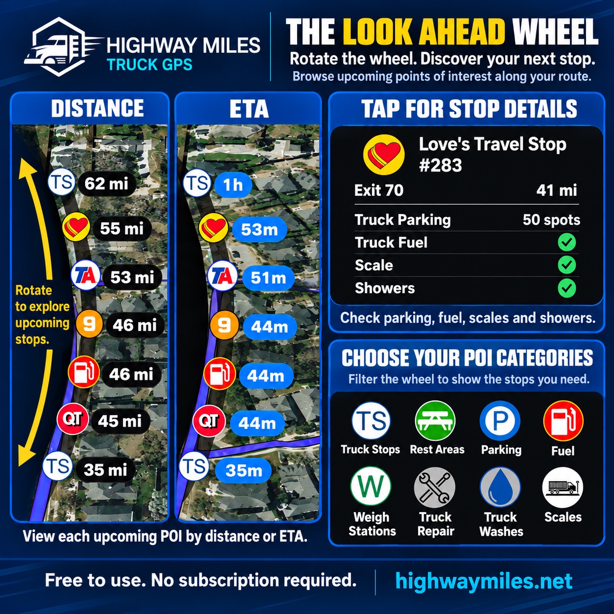
After navigation begins, the Look Ahead Wheel helps you review upcoming services by distance or estimated time. This Highway Miles instructional graphic contains app-screen examples; its estimates and facility details are illustrative, not current reports. A listed parking capacity is not live vacancy.
What helps during the workday?
Understanding the route and the next maneuver
Commercial routing uses your truck profile rather than treating the trip as a passenger-car journey. Turn-by-turn voice and lane guidance help keep the next move clear. Highway Miles also uses actual moving speed and the configured maximum or governed truck speed in its ETA calculations. An ETA remains an estimate: traffic, stops, loading delays and changing conditions can alter arrival time.
Low Bridge Awareness brings available low-clearance information into route review and navigation. Treat it as additional awareness—not confirmation that every bridge or restriction is known. Read more about clearance information and vehicle settings.
Checking traffic and weather together
The app provides available congestion, incident, construction and closure information, plus weather information and radar around the route. These tools help you examine what lies ahead and reconsider a stopping plan when conditions change.
Live data is not instantaneous or complete. A missing incident marker does not prove the road is open, and radar does not guarantee conditions when you arrive. Use current official alerts for important weather decisions. Our road-information guide and weather-radar overview explain those coverage limits.
Finding services and possible stopping locations
Truck-focused listings include truck stops, rest areas, parking, fuel, weigh stations and other driver services. The Look Ahead Wheel supplies time or distance context for upcoming locations, helping you consider a stop before reaching its exit.
Keep the distinctions clear: a parking location is not a confirmed available space; a fuel-stop listing is not a verified current diesel price; and a weigh-station location does not authorize a bypass. Check critical access, opening hours and services with the location. See the truck-stop and services overview.
Reviewing the delivery approach and adjusting the trip
Satellite imagery and available Street View access help you examine a property's layout and possible approaches. They cannot certify the commercial entrance, current gate rules, overhead clearance or turning room. Confirm uncertain receiving instructions directly; our truck-entrance preparation guide explains what to ask.
Avoid and Route Through Here are released route controls, documented in the app-store release notes. They let you request a route adjustment around a selected point or through a selected location. Review the resulting route: these controls do not override a restriction or guarantee that a chosen point is accessible to your truck.
What works offline—and what is not established?
Downloaded maps and offline routing are different capabilities. The official offline-map documentation confirms supported map downloads but does not promise fully offline truck navigation. Here is what that means for separate operations:
Viewing downloaded maps
Documented: supported map downloads provide map coverage for reference in low-connectivity areas. Download the relevant region beforehand and confirm that the download completed.
Continuing an already active navigation session
Not verified end to end without data. The current documentation does not establish which active-session functions continue, for how long, or after an app restart. Do not infer uninterrupted guidance from the ability to see a downloaded map.
Calculating a new route
Offline calculation is not verified. Product documentation says route calculation may still require a data connection. Plan while connected before entering a low-coverage area.
Rerouting after a deviation
Offline rerouting is not verified separately. Seeing an existing route does not prove the app can calculate a replacement without data. Documentation says rerouting may require connectivity.
Receiving live traffic and weather
Fresh updates require connectivity. Previously displayed information should not be treated as a current report after the connection is lost.
“Not verified” means the evidence is insufficient, not that the function is proven unavailable. If dependable offline calculation and rerouting are essential to your work, retain an independently verified solution until those operations are confirmed for your Highway Miles version and device.
The limits every driver should understand
Highway Miles is a navigation aid. It does not guarantee the safest or most accurate route, prevent every bridge strike, detect every restriction or know every temporary road change. Correct vehicle information and careful route review remain necessary.
Follow posted roadway controls, applicable restrictions and permit requirements. Verify uncertain delivery approaches. Never make an unsafe turn or maneuver just to satisfy a prompt. These practices align with FMCSA's guidance on using GPS in commercial vehicles.
Do not treat the phone app as an ELD, emergency-dispatch service or fleet-management platform. Navigation and optimization do not replace your carrier's operating procedures or your responsibility for the workday.
Two common questions
Do I need Ad-Free to plan more stops?
No. Unlimited-stop planning and optimization are included in the released free phone plan. The optional subscription removes advertising; it is not an upgrade to a larger stop allowance.
Does “free” mean my phone and mobile data cost nothing?
No. Free describes the Highway Miles navigation plan. You still need a compatible device, power and connectivity for network-dependent functions; your normal device and carrier costs are separate.
Who should try Highway Miles?
If you want a truck GPS app for CDL drivers with free phone-based commercial navigation, flexible multi-stop planning and useful route information together, Highway Miles is a practical app to try. Owner-operators, company drivers and newer CDL drivers can evaluate that workflow without first buying a navigation subscription.
Our recommendation is to start with the free plan, set up the correct truck profile and review a familiar trip while parked. Consider Ad-Free if removing advertising is worth the monthly price to you. Another product deserves consideration when it provides a specific capability you need, such as verified offline routing or a dedicated navigation device.
Download Highway Miles for iPhone or Android and prepare your first route. If you are still weighing alternatives, read our comparison of the best truck GPS apps.